BIRDLIFE IN THE WARRIEWOOD WETLANDS
History
HISTORY
In 1824 , James Jenkins was given 1,000 acres (405 hectares) in the Warriewood Valley and the following year a further 250 acres (101 hectares). He called it Cabbage Tree Hill Farm as Cabbage tree palms abounded there and the fronds were used for thatch and hats, the trunks for fencing and building, and the pith for feeding livestock. The ironbark, stringybark, grey gum, turpentine, mahogany and forest oak trees were used for building, fencing, firewood and other purposes.
In 1829 Jenkins had cleared 17 acres (7 hectares), built a weatherboard cottage, owned 14 horses and 440 horned cattle. Later, the Macpherson family farmed Jenkins's land, and it became Warriewood. Farm produces were taken to Sydney via Lane Cove Road, or overland to Manly and then by ferry to Sydney.
In 1906 the land was subdivided and advertised as suitable for both residential and farm blocks. In the 1920s, George Dunn moved to Warriewood to help on the family farm with his eight siblings. As an adult, he collected tomatoes in crates from local farms in the evening and took them to market, leaving at 3 am, every day of the week.
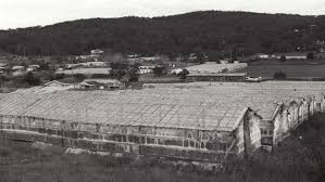
In 1925 Roseville Bridge opened, and then in 1932 the Harbour Bridge, making it much easier to get goods to market in Sydney. Field crops such as beans, potatoes, lettuce, carrots, peas, cabbage, marrow, beetroot and capsicum were cultivated. Several migrant families came from Broken Hill after the depression in the mining industry in 1932. Home to Italians then called Yugoslavia. Some Yugoslav families would offer work to newly arrived fellow-countrymen. Warriewood housed 3,500 glasshouses. Production was at its peak in the period between 1947 and 1954, and 100 pounds (45 kilograms) of tomatoes per glass house each year was a profitable return.
From 1951, the state government restricted development in this area, as it was unable to provide the necessary infrastructure – water and sewerage. No building was allowed on any block smaller than two hectares (five acres) and rural zoning was established and maintained for this area.
By the 1960s, market gardening in the area had declined because produce shipped from other states was cheaper. As a result, some farmers redeveloped their land into nursery gardens. Some areas along Pittwater and Mona Vale Roads were rezoned to allow for commercial development. However, residential subdivision was only achieved
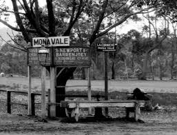
In 1991 under the state government urban development plans. From then, the rural character of Warriewood began to change, as the valley became a suburb. There was considerable planning for infrastructure (water, roads and other services) to accommodate more than 1,500 residential blocks and more than 5,000 people. Today streets are named by the tomatoes types which grew once in this area like Apollo, Daydream, Jubilee and Ponderosa.
In 1996, the Council purchased the wetlands to protect this ecosystem after the construction of the Shopping Centre. In 1947, Henry Roth a Polish refugee purchased the wetlands and sold them in the 1970’s to the Warriewood Shopping Centre.
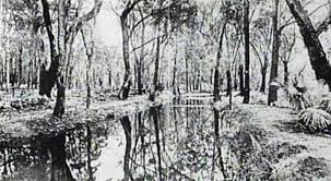
Today, Warriewood Wetland is a well-preserved ecosystem of approximately 26 hectares and plays a vital role in flood mitigation, nutrient recycling and filtering sediments. A 2.4km walkway network was built and it provides a great way for bird watchers to enjoy their passion.
The Wetlands are the largest remaining in the Northern Sydney area. They provide a variety of habitats for native birds and other Endangered Ecological Communities.
The Wetlands are popular with Sydney's birdwatching community, particularly in May in autumn when the swamp mahogany trees are in flower.
Sources:
Margrit Koettig, 'Ingleside Warriewood Urban Land Release Assessment of Aboriginal Sites', 1993 Joan Lawrence, Pittwater Paradise, Kingsclear Books, Crows Nest, NSW, 1994 Joan Lawrence, Pittwater Pictorial History, Kingsclear Books, Alexandria, NSW, 2006 John Morcombe, 'Rural nature disappearing', Manly Daily, 4 April 2000 Mary Stenning, 'Yugoslav Tomato Glass House Growers, Warriewood, Manly Warringah Journal of Local History, vol 6, March, 1995 Tropman and Tropman Architects, 'Ingleside Warriewood Urban Land Release Heritage Study', 1993